The Golan Heights is a volcanic plateau the size of a small European country, rising sharply from the eastern shore of the Sea of Galilee to a flat, windswept landscape of basalt rocks, rolling grasslands, and some of the most contested real estate in the Middle East. It is also one of the most beautiful, surprising, and historically rich regions in Israel, and most visitors who spend a day there wonder why they did not spend a week.
Volcanic Plateau Above the Rift – Golan Heights
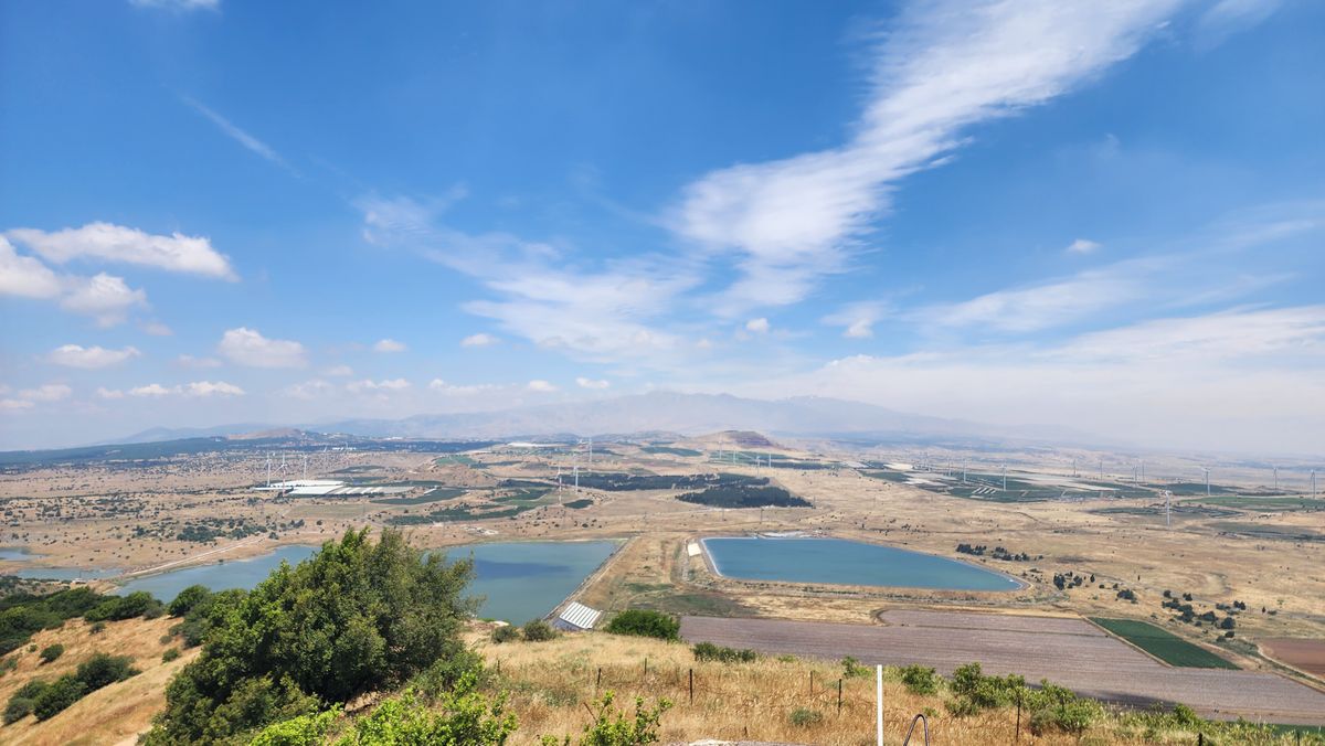
The Golan Heights is a basalt plateau formed by volcanic activity over millions of years. The Sea of Galilee is a freshwater lake lying about 210 meters below sea level — an integral part of the Syrian-African Rift, a transform fault — with the Golan Heights rising steeply to the east. The plateau is roughly 65 kilometers long and 25 kilometers wide, bordered by the Sea of Galilee and the Jordan River to the west, Mount Hermon to the north, and the Yarmouk River to the south.
The landscape is unlike anything else in Israel. Where the rest of the country is limestone and sand, the Golan is basalt and rich volcanic soil. The rocky fields are punctuated by ancient dolmens, mysterious stone structures dating back thousands of years. In spring, the plateau erupts in wildflowers. In winter, it can be covered in snow. And year-round, the views from the western edge, looking down at the Sea of Galilee 600 meters below, are among the most dramatic in the country.
A Brief History
The Golan Heights has been inhabited since prehistoric times. Ancient dolmens, Chalcolithic settlements, and Bronze Age cities are scattered across the plateau. In the biblical period, the Golan was part of the territory assigned to the half-tribe of Manasseh. During the Roman and Byzantine periods, the Golan was home to a thriving Jewish community. Some approximately 25 to 30 ancient synagogues have been identified on the plateau, most of them dating to the Byzantine period (5th-7th centuries CE). The sole exception is the synagogue at Gamla, which dates to the Roman period and is one of the oldest synagogues found in Israel. The Crusaders built Nimrod Fortress on its slopes. And the Ottomans administered it as part of greater Syria.
In the modern era, the Golan was part of Syria from 1946 to 1967. During those years, Syrian forces on the heights regularly shelled Israeli communities in the valleys below, and the Golan became synonymous with a strategic threat. Israel captured the Golan Heights during the Six-Day War in June 1967, survived a massive Syrian counterattack during the Yom Kippur War in 1973, and formally applied Israeli law to the territory in 1981.
The status of the Golan Heights remains internationally disputed, though the United States recognized Israeli sovereignty over the Golan in 2019. For the approximately 50,000 people who live on the Golan today, roughly half Israeli Jews and half Druze, the plateau is simply home.
What to See on the Golan Heights
The Golan Heights packs an extraordinary amount into a small area. Military history sites like Mount Bental, Tel Fakher, and Tel Saki tell the story of the wars that shaped the plateau. Ancient sites like Gamla, Katzrin, and Umm el-Kanatir reveal the Jewish communities that thrived here two thousand years ago. Nimrod Fortress is the largest medieval castle in the region. Banias and Tel Dan combine archaeology with some of the most beautiful nature in Israel. The wineries produce world-class wine. The Druze villages offer hospitality and cuisine that are unlike anything else in the country. And the landscape itself, volcanic, green, windswept, and wide open, is a constant companion.
Visit with Hoshen Tours
The Golan Heights deserves more than a quick stop at a viewpoint. Hoshen Tours designs Golan itineraries that combine the natural beauty, military history, archaeology, wineries, and Druze culture into experiences that reveal the full depth of this extraordinary plateau.
Because the Golan Heights is not just a place on the map. It is a world of its own, a thousand meters up, with stories and views that will stay with you long after you come back down.
Explore Our Tour Collection
Ready to experience Israel in true colors?
Plan Your TourPrivate tours designed around your interests, schedule, and pace.