 The Aqueduct Beach at Caesarea Israel in Israel is one of the most spectacular stretches of coastline in Israel. A long, wide sandy beach with the remains of a Roman aqueduct running along the sand, its arches framing the Mediterranean. The aqueduct carried fresh water from springs at the foothills of Mount Carmel to the city of Caesarea, a distance of roughly 10 to 13 kilometers depending on the route.
Water for a Growing City
When Herod the Great founded Caesarea in the late 1st century BCE, the city relied on wells, cisterns, and local reservoirs for its water supply. These systems were sufficient for the initial population, but as Caesarea grew into one of the largest cities in the Roman East, the demand for fresh water outpaced what cisterns could provide. The solution was an ambitious engineering project: a high-level aqueduct that would bring water by gravity from natural springs near Shuni, at the foot of Mount Carmel, all the way to the city.
Archaeological evidence, particularly the work of Yosef Porath of the Israel Antiquities Authority, indicates that the first channel (Channel A) was built during the Flavian period, roughly 69 to 96 CE, well after Herod’s death. The channel was lined with waterproof plaster and covered to prevent evaporation, running on a series of stone arches wherever the terrain dipped below the required gradient. The engineering was precise: the entire system relied on gravity alone, with no pumps, maintaining a consistent downward slope across the full distance. A second, longer water source also fed the city: the Mei Kedem tunnel system, fed by the Tzabarin springs further north in the Carmel foothills, carried water through roughly 6 kilometers of underground tunnel before emerging on its way south to Caesarea, extending the total reach of the city’s water network to over 22 kilometers. This tunnel system was distinct from the Shuni-fed High-Level Aqueduct and shows just how seriously Roman engineers planned for the needs of a growing city.
Hadrian’s Expansion
When Emperor Hadrian visited Caesarea around 130 CE, the city’s population had grown further and a single channel was no longer enough. Hadrian ordered a second parallel channel (Channel B) built alongside the first, effectively doubling the water supply. Four Roman legions participated in the construction: Legio X Fretensis, Legio VI Ferrata, Legio XXII Deiotariana, and Legio II Traiana Fortis. Latin inscriptions carved into the aqueduct stones record their names, though some of these inscriptions may date to earlier construction phases rather than to Hadrian’s expansion, still legible on some blocks today. The Legio X Fretensis had participated in the destruction of Jerusalem in 70 CE, and seeing their name carved into the stones of an aqueduct they built decades later adds a human dimension to the Roman military presence in the region.
A separate ground-level aqueduct (the Low-Level Aqueduct) later brought additional water from the Nahal Taninim dam. Together, these systems supplied a city estimated at up to 50,000 inhabitants with enough water for its bathhouses, fountains, public buildings, and gardens. The aqueducts continued to function for roughly six centuries, until the Islamic conquest of 640 CE.
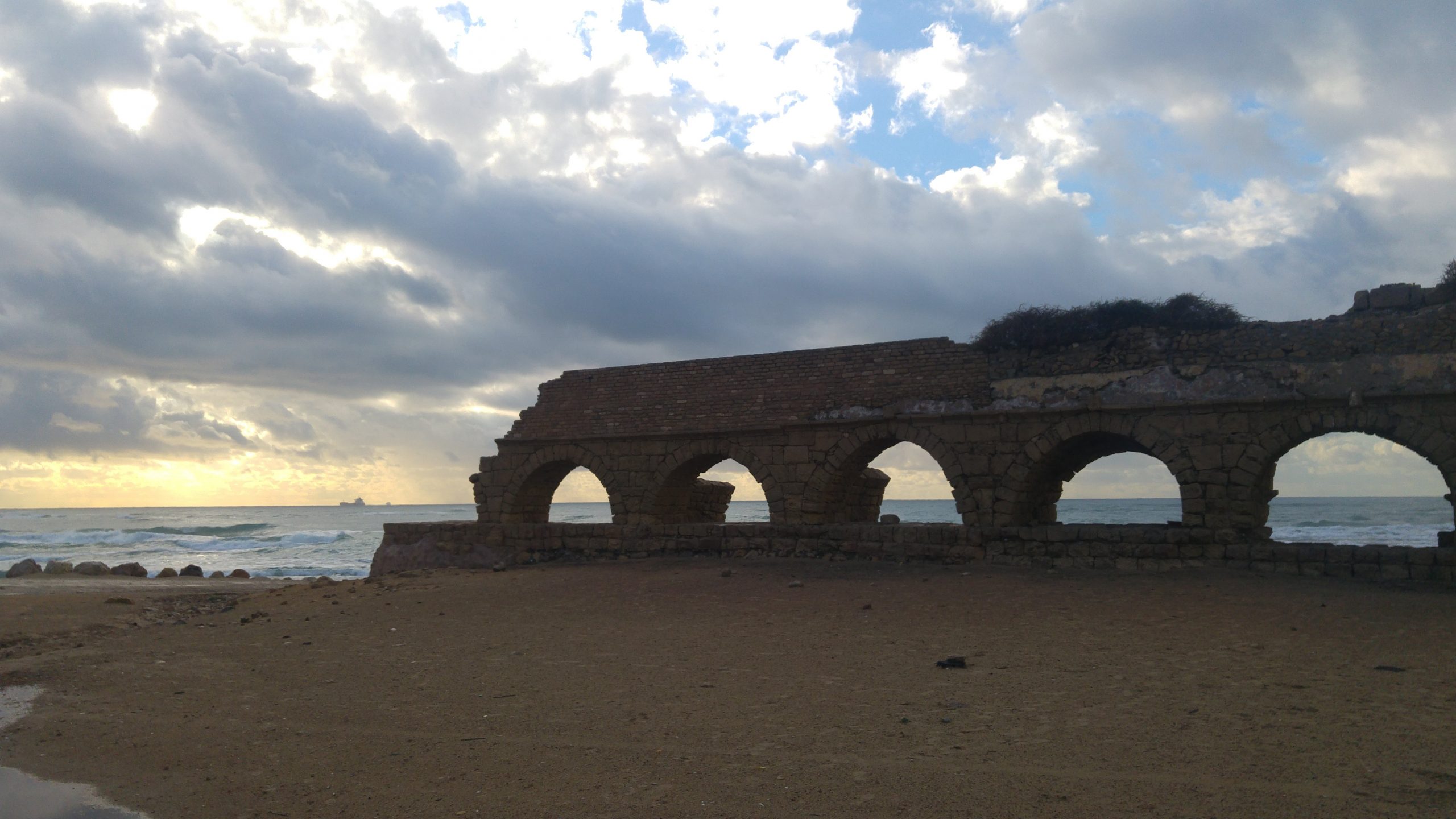
The Aqueduct Beach at Caesarea
The section of aqueduct that survives on the beach is the most dramatic visible stretch of the entire system. The Roman arches rise directly from the sand, with waves breaking around their bases at high tide. At sunset, the stone glows amber and gold against the darkening sea. The double-arched profile, where the two channels run side by side, is clearly visible. The beach itself is long, wide, and sandy, one of the best swimming beaches on the Mediterranean coast. Unlike the Caesarea National Park to the south, the aqueduct beach is free and open to the public, accessible from a parking area just north of the ancient city.
Visit with Hoshen Tours
A visit to Caesarea Aqueduct pairs beautifully with nearby destinations along your route. Consider combining it with a stop at Caesarea or Ramat HaNadiv, both just a short drive away. Many travelers also enjoy exploring Nahal Taninim and Tel Dor on the same day, while Habonim Beach offers another worthwhile addition to your itinerary. Your Hoshen Tours guide will craft a seamless route that brings each destination to life with expert commentary and insider knowledge.
Explore Our Tour Collection
Explore this site and 65 more in Sacred Steps in the Holy Land
225 pages · The Life, World, and Footsteps of Jesus · Maps, photos, and Scripture references
Ready to experience Israel in true colors?
Plan Your TourPrivate tours designed around your interests, schedule, and pace.