Metula, founded in 1896 by Jewish settlers from Russia with funding from Baron Edmond de Rothschild, is the northernmost town in Israel. It sits at the tip of a narrow strip of territory that protrudes into Lebanon like a finger, surrounded on three sides by the Lebanese border, with orchards, stone houses, and a frontier atmosphere unlike anywhere else in the country. The residents grow apples, run a surprisingly popular ice rink, and have been living on the edge, literally, for over a century.
The Founding
Metula was established in 1896 when Baron Edmond de Rothschild purchased land at the very northern tip of the region and helped settle a group of Jewish families from Russia. It was one of his later investments in the network of agricultural settlements he supported across the Galilee, and it shared the characteristic features of his other villages: solid stone houses with red-tiled roofs, agricultural infrastructure, and a European-influenced architectural style built to last. The founders planted orchards of apples, pears, and other fruit trees that take advantage of the cooler mountain climate of this elevated location, and Metula’s orchards have remained a defining feature of the town ever since. The fruit trees that line the approaches to town in spring blossom are among the most beautiful sights in the Upper Galilee.
Rehov HaRishonim
The main street of old Metula, Rehov HaRishonim (Pioneers Street), is lined with stone buildings from the founding period. The architecture reflects the Rothschild era: solid, European-influenced houses with red-tiled roofs and thick walls, built by settlers who intended to stay. Walking along HaRishonim gives a vivid sense of what the early Jewish agricultural settlements in the Galilee looked like before the concrete apartment blocks of later decades changed the landscape of northern Israel. The street’s quiet, unhurried character, the orchards at the ends of garden paths, the stone walls warm in the afternoon sun, feels genuinely different from anywhere else in Israel.
Finger of the Galilee
Metula exists in its current shape because British negotiators insisted on including it within the Mandate territory during the border negotiations of the 1920s. The resulting bulge in the border, known as the “finger of the Galilee”, has made Metula one of the most geographically exposed communities in Israel, with the Lebanese border close on three sides. The town’s location at the tip of the finger means that on a quiet day, you can hear roosters crowing in Lebanese villages a few hundred meters away. The Lebanese border literally runs at the edge of town.
The Iyyon Stream and Tanur Waterfall
Just below Metula, the Iyyon Stream (Nahal Iyyon) carves a narrow gorge through the Upper Galilee hills on its way to join the Hatzbani River. The Iyyon Reserve encompasses several waterfalls along the stream’s course, of which the most impressive is Tanur (“the oven”), a dramatic fall that drops into a dark basalt pool surrounded by ferns and thick vegetation. The falls are accessible on a marked trail through the forest and are one of the most scenic natural features in the Upper Galilee, particularly striking after winter rains when the water volume is high. The sound of running water in this otherwise dry landscape is remarkable, and the trail through the gorge passes under cliffs that drip with moisture even in summer.
The Hatzbani River
The Hatzbani is one of the three main tributaries of the Jordan River, rising in Lebanon and flowing south through the Upper Galilee before joining the Dan and Banias streams at the headwaters near Tel Dan. In the area around Metula, the Hatzbani flows through a landscape of willows and poplars, its banks green year-round in contrast to the drier hillsides above. The river has long been one of the most beautiful watercourses in northern Israel, and the valley it creates between the hills of the Upper Galilee and the Lebanese border carries a particular tranquility that visitors find striking. It is possible to walk sections of the riverbank on marked trails connecting to the broader network of Upper Galilee footpaths.
Canada Centre
Metula’s most unexpected attraction is the Canada Centre, an ice sports complex donated by Canadian Jews in 1990. It includes an Olympic-sized ice rink, a swimming pool, and a bowling alley. The sight of Israelis ice skating a few hundred meters from the Lebanese border is one of those details that captures something essential about life in Israel: the determination to live normally in circumstances that are anything but. The rink has produced Israeli national figure skating and ice hockey teams, and it draws visitors from across the north year-round.
Good Fence
During the Lebanese Civil War, the border at Metula became known as the Good Fence, a crossing point where Lebanese civilians could enter Israel for medical treatment and work. The arrangement emerged from the chaos of the civil war, which drove many residents of southern Lebanon to seek help across the border. Israel maintained the crossing as a humanitarian gesture and as a way to build relationships with neighboring communities. The Good Fence crossing operated from the mid-1970s and closed when Israel withdrew from southern Lebanon in 2000. It represents one of the more unusual chapters in the history of this border town.
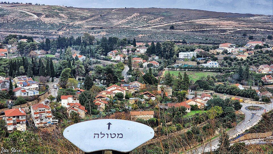
Mitzpe Dado
Mitzpe Dado (the Dado Lookout) is a viewpoint at the edge of town named after David Dado Elazar, the IDF Chief of Staff during the Yom Kippur War. The lookout offers sweeping views into the hills and valleys to the north. For years, this was a place where visitors could stand at the edge of Israel and contemplate how close the world beyond the border actually is. The view from Mitzpe Dado, with the orchards of Metula below and the hills of Lebanon rising beyond, is a fitting summary of what makes this small town unlike anywhere else in Israel.
Visit with Hoshen Tours
Metula is a natural stop on northern border itineraries. Hoshen Tours combines it with Tel Hai, Tel Dan, and the Hula Valley for a day that takes in the headwaters of the Jordan, the pioneer history of the north, and the unique frontier atmosphere of Israel’s northernmost town.
Explore Our Tour Collection
Ready to experience Israel in true colors?
Plan Your TourPrivate tours designed around your interests, schedule, and pace.