Driving north through the Jordan Valley on Route 90, Tel Hazor Israel comes into view long before arrival. The massive mound rises above the plain like a green-shouldered giant, impossibly large and obviously ancient, commanding everything around it. Even from a distance, the scale communicates something essential about what this place once was.
The upper tel, the high flat summit, covers 30 acres on its own. To the north, across the road, an enormous flat expanse stretches nearly a mile, ringed by the faint ghost of ancient earthen ramparts. That was the lower city. Together, the site totals 200 acres. At its peak, 15,000 people lived here. Jerusalem in the era of King David covered roughly 12 acres. Hazor was not merely a large city in the ancient world. It was the city, described in the Book of Joshua as “the head of all those kingdoms.”
A Crossroads of the Ancient World
The upper tel is reached by a paved walkway winding through low scrub, past open excavation trenches, over ground that has been occupied, destroyed, rebuilt, and destroyed again more than two dozen times across four thousand years. Twenty-two distinct layers of civilization are stacked in the soil, each one the compressed record of a community that once thrived here.
From the summit, the full strategic logic of the site becomes clear. To the west, the Galilee hills roll away toward Acre and the Mediterranean. To the east, the dark bulk of the Golan Heights. To the north, the valley leads toward Dan and, beyond it, the slopes of Mount Hermon still carrying snow in spring. Every army, every merchant caravan, every Egyptian envoy approaching from the south would have seen this tel rising on the horizon. Visibility was a form of power, and Hazor wielded it for millennia.
The city sat at the crossroads of the ancient Near East. The great trade road between Egypt and Mesopotamia, known as the Via Maris, passed close enough that Hazor controlled access to it. Egyptian pharaohs knew this place by name, and ancient archives from as far away as Syria and Egypt mention Hazor’s kings and merchants by name. This was no provincial backwater. It was a place where the ancient world conducted its most consequential business.
The Conquest Layer: Evidence in the Ash
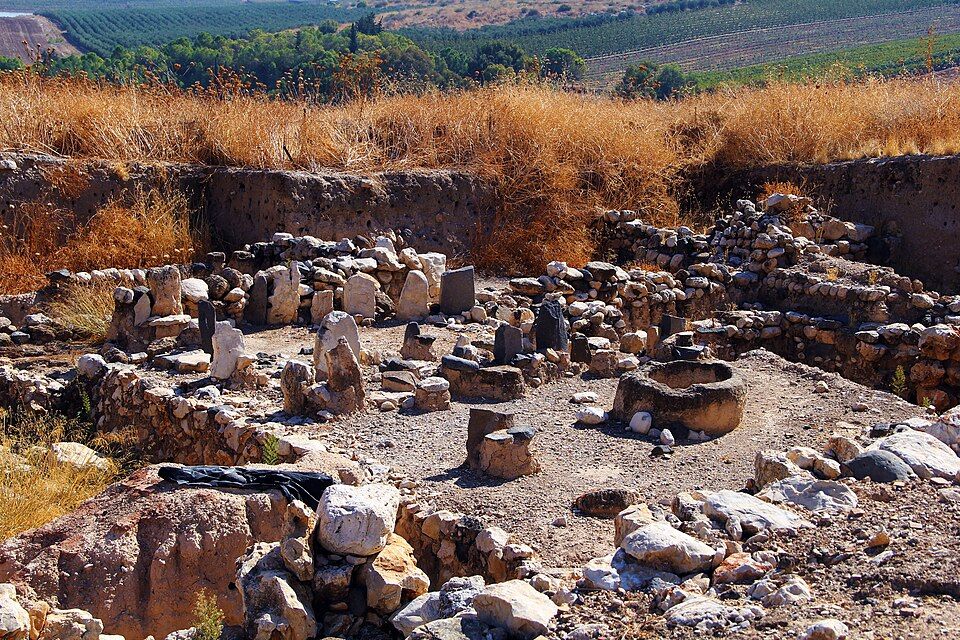
The Book of Joshua presents one of its most dramatic episodes at this site. The kings of northern Canaan, assembled under Jabin of Hazor, mustered their forces at the Waters of Merom. Joshua led an Israelite coalition against them, routed the alliance, then turned back and burned Hazor. Of all the cities in the northern campaign, only Hazor was put to the torch. The text is precise on this point.
The excavations found the fire. A massive destruction layer from around the 13th century BCE contains collapsed mudbrick, charred timbers, and thick ash. Among the ruins of Canaanite temples and cultic spaces, the evidence of deliberate destruction is unmistakable. Statues of Canaanite deities were found with their heads smashed off and hands broken away. Someone came through and methodically decapitated the gods of Hazor. The shattered basalt figures, now displayed in the site museum, carry that weight with them. Whether or not one connects them to the biblical account, the destruction itself is not in dispute.
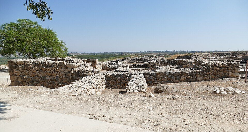
The Solomonic Gate
Near the summit of the upper tel, a gate complex stands as one of the most significant finds in the entire country. Six chambers, three on each side of a central passageway, built from large carefully dressed stones. The walls still stand to shoulder height in places, and the full length of the passage runs about 15 meters. The chambered design would have funneled visitors, controlled movement, and made entering the city a deliberate, almost ceremonial act.
This is a Solomonic gate, built in the 10th century BCE. The Book of Kings records that Solomon fortified three cities: Hazor, Megiddo, and Gezer. When Israeli archaeologist Yigael Yadin excavated here in the 1950s and uncovered this gate, he recognized its significance immediately. He had already seen nearly identical gates at the other two sites. Three cities, three gates, the same plan, the same dimensions, the same period. The blueprint matched across all three locations. The gate at Tel Hazor stands as one of the clearest physical confirmations of the biblical text ever uncovered in the field.
Beyond the gate, the upper city functioned as a planned administrative center, with a governor’s residence, royal storehouses, and a citadel. This was not a sprawling organic town but something organized and intentional, built to project authority across the northern region. Solomon understood Hazor’s strategic value and built accordingly.
The Water Shaft
At the northern end of the upper tel, a staircase descends into the earth. Not a few ceremonial steps, but a genuine descent into the ancient infrastructure of survival. The shaft was cut in the Iron Age, likely during the 9th century BCE, when controlling a reliable water source inside the city walls was a matter of life and death. Springs lay outside the walls. Sieges were common. So the engineers of Hazor solved the problem through sheer determination: they cut a shaft approximately 40 meters straight down through layers of ancient occupation and then through bedrock to reach the water table below.
The staircase spirals around the inside of the shaft as it descends, wide enough that people and pack animals could pass each other on the stairs, donkeys carrying empty jars down and full jars back up. The air cools steadily as the depth increases. The walls press in. At the bottom, the chamber opens out to where the water once pooled. The entire system represents a staggering feat of engineering, conceived, planned, and executed nearly 3,000 years ago without modern tools or modern calculations, driven entirely by the need to keep a city alive inside its walls.
The shaft is the feature visitors most frequently describe as lingering in memory longest, and the reasons are obvious. The physical experience of descending into Iron Age infrastructure, below everything ever built on top, makes history tangible in a way that no display case can replicate.
The Assyrian End
In 733 BCE, the Assyrian king Tiglath-Pileser III swept north through the Galilee. The Book of Kings records the campaign in brief strokes: city after city fell across the region, and Hazor fell among them. The Assyrian destruction layer at the site is unmistakable, a dense band of ash and collapsed mudbrick that marks a precise moment in history. After that moment, Hazor never recovered.
The city that had dominated the Canaanite world for more than a thousand years simply stopped functioning as a major center. A few scattered settlements came later, but the age of Hazor as a living, functioning city was finished. The vast lower city, which had once held 15,000 people, became farmland and pasture for most of the following 2,700 years. The earthen ramparts are still visible if one knows where to look, a faint ridge running around the perimeter, all that remains above ground of what was once the largest city in Canaan.
The Site Museum
The museum near the site entrance houses artifacts that reward careful attention. The collection includes some of the most significant Canaanite material culture found anywhere in the country.
The basalt lion orthostat, a carved lion that once flanked the entrance to a Canaanite temple, has presence far exceeding its physical size. The stone is dark and dense, the carving confident. Three thousand years ago this lion stood at a temple doorway, marking the threshold between the ordinary world and the sacred. The intention is still legible in the stone.
Bronze figurines in the collection include deity figures with raised arms in gestures of power or blessing, some seated, some standing. Among them are figures with missing heads, recovered from the same destruction layer as the larger statues on the tel, broken in the same deliberate manner. The museum display makes the act of destruction visible in physical form.
Cuneiform tablets found at the site confirm that Hazor’s elite were literate in the international administrative script of the ancient Near East, conducting business and correspondence in the same language used from Babylon to Egypt. The tablets place Hazor squarely at the center of ancient Near Eastern commerce and diplomacy, not at its fringes.
Visiting
Tel Hazor was designated a UNESCO World Heritage Site in 2005, alongside Megiddo and Beer Sheba, as part of the “Biblical Tels” inscription. The designation reflects the site’s exceptional archaeological significance, but the experience of visiting goes well beyond credentials.
The scale of the place is difficult to convey in advance. The Solomonic gate is traversable on foot. The water shaft is open for descent. The excavation trenches along the upper tel expose layers that span four millennia. The view from the summit takes in the full geography that made this site matter: the valley routes, the distant ridgelines, the agricultural plain below. Every civilization that chose this location understood the same things about it, and those things are still visible from the top of the mound.
Two hours is a reasonable minimum for the site and museum together. The water shaft descent is worth the effort and requires solid footwear. Morning visits offer the best light across the Galilee hills, with the Jordan Valley spread below and Mount Hermon visible to the north on clear days.
Explore Our Tour Collection
Ready to experience Israel in true colors?
Plan Your TourPrivate tours designed around your interests, schedule, and pace.