Mount Precipice, known in Hebrew as Har HaKfitza, the Mountain of the Leap, is the dramatic limestone cliff at the southern edge of Nazareth, where the Nazareth ridge drops steeply toward the Jezreel Valley far below. Tradition identifies this escarpment as the “brow of the hill” described in Luke 4: the place where the people of Nazareth, furious at Jesus after his synagogue sermon, tried to throw him off a cliff. He walked through the crowd and continued on his way. The site combines one of the most charged moments in the Gospels with one of the finest panoramic views in all of the Galilee.
The Gospel Story: Luke 4:16–30
Jesus had returned to Nazareth, his hometown, where he had grown up, after his baptism in the Jordan and his forty days of testing in the wilderness. On the Sabbath, he went to the synagogue, as was his custom, and was handed the scroll of the prophet Isaiah. He unrolled it and read aloud: “The Spirit of the Lord is upon me, because he has anointed me to proclaim good news to the poor. He has sent me to proclaim freedom for the prisoners and recovery of sight for the blind, to set the oppressed free, to proclaim the year of the Lord’s favor” (Luke 4:18–19, quoting Isaiah 61:1–2). Then he rolled up the scroll, handed it back to the attendant, and sat down. Every eye in the synagogue was fixed on him. He said: “Today this scripture is fulfilled in your hearing” (Luke 4:21).
The Gospel Connection
The crowd was initially impressed, Luke says they “spoke well of him and were amazed at the gracious words that came from his lips”, but their admiration quickly curdled into suspicion. They muttered: “Is this not Joseph’s son?” Jesus answered with a proverb: “No prophet is accepted in his hometown.” He then pointed to two episodes from Israel’s own history: tradition holds that Elijah was sent to a widow in Sidon, a foreigner, and that Elisha healed Naaman the Syrian, a foreign general: not one of the many widows and lepers in Israel. The implication that God’s grace reaches beyond the boundaries of Israel enraged them. “All the people in the synagogue were furious when they heard this. They got up, drove him out of the town, and took him to the brow of the hill on which the town was built, in order to throw him off the cliff. But he walked right through the crowd and went on his way” (Luke 4:28–30).
Christian tradition understands this as the first public rejection of Jesus: not by strangers, but by the people who had known him all his life. The sermon at Nazareth is often treated as a kind of inaugural address for his ministry, and its rejection marks the turn toward Capernaum, the fishing town on the Sea of Galilee that would become his base. Nazareth, the hometown, could not accept what it had raised.
The Cliff: Geology and Tradition
The escarpment at the southern rim of the Nazareth ridge reaches approximately 400 meters above sea level and drops steeply toward the Jezreel Valley floor, which lies at roughly 50–80 meters. The cliff face is part of the Lower Eocene limestone formation running along the southern edge of the Lower Galilee hills, shaped over millions of years by geological faulting along the fault system that created the valley trough below. The rock is pale grey-white limestone, pitted and weathered, and the drop from the cliff edge toward the valley is both sheer and dramatic, steep enough that standing at the top makes the valley floor look very far away.
The identification of this cliff as the “brow of the hill” of Luke 4 dates back at least to the Crusader period, when medieval pilgrims recorded visiting the site as part of their Nazareth itinerary. An alternative tradition places the event closer to the old city center, near a smaller rocky outcrop by the Maronite church, on the grounds that the synagogue and the cliff would have needed to be in close proximity. Both identifications are traditional rather than archaeologically proven. The dramatic southern escarpment has long been the more widely cited location and is the one recognized in the pilgrimage tradition as the Mount of the Leap.
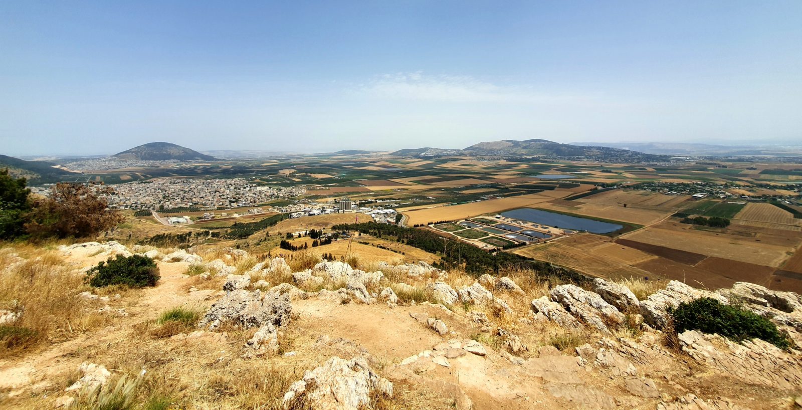
The Panoramic View: Biblical History Spread Below
Standing at the edge of Mount Precipice, the entire Jezreel Valley opens before you in one of the most commanding views in the Land of Israel. The valley stretches roughly 36 kilometers from west to east: from the Carmel ridge in the west, near the ancient mound of Megiddo, all the way across to the Jordan Valley in the east. It is broad, flat, and agriculturally rich, and in antiquity every major route connecting Egypt and Arabia to Syria, Mesopotamia, and Anatolia passed through it. To stand here is to stand above the highway of empires.
The landmarks visible from the cliff trace centuries of biblical narrative. Mount Tabor rises to the northeast, an isolated, dome-shaped hill, unmistakable on the horizon, the site where tradition holds that Deborah the judge and Barak the general assembled the Israelite tribes and descended to defeat Sisera and his nine hundred iron chariots at the Kishon River (Judges 4–5). To the southeast, the Gilboa range, the long ridge where Saul fell on his sword after the Philistines routed the Israelite army, and where Jonathan died beside him (1 Samuel 31), runs along the valley’s southern edge. To the southwest, on a low rise above the valley floor, the mound of Megiddo (Armageddon) marks the ancient pass through the Carmel ridge: the strategic chokepoint that every army from Thutmose III to Napoleon used when crossing this land.
Closer in, the Hill of Moreh, the rounded hill rising from the valley floor to the south, is where tradition holds the Midianite army camped before Gideon chose his 300 warriors from the spring of Harod at the base of Gilboa (Judges 7). Just beyond it lies the village of Nain, where Luke records that Jesus raised a widow’s son from the dead (Luke 7:11–17). The modern city of Afula sits on the valley floor at the ancient crossroads. On clear days, the view extends from the Carmel ridge in the west to the hills beyond the Jordan in the east: an entire sweep of landscape that shaped the biblical world.
Growing Up With This View
This landscape was the backdrop of Jesus’ childhood. Nazareth sat on the northern rim of the Jezreel Valley, and the view from the ridge above the village would have been part of daily life for a boy growing up there. The stories of Deborah and Barak, of Gideon and his torches, of Elijah on Carmel, of Saul and Jonathan on Gilboa, were not distant mythology for a first-century Jewish family in Nazareth; they were the landscape that generations read their scriptures against. The valley below held the memory of the nation.
Teachers of the Gospels often note how Jesus drew his images from the world immediately around him: fields, vineyards, shepherds, grain, weather. He spoke of watching the clouds come from the west over Carmel and knowing rain was coming (Luke 12:54). The wide valley below, its agricultural rhythms, its ancient roads, its remembered battles: all of it formed the world in which his parables were shaped. The cliff at Mount Precipice is not simply the place where a crowd tried to kill him. It is the edge of the world he grew up knowing.
Architecture and Stonework
The Jezreel Valley, called Emek Yizrael in Hebrew, is one of the most contested stretches of ground in the ancient world. Its flatness and fertility made it essential, and its position as the only broad east-west corridor through the hill ranges of the Galilee and Samaria made it a military route through which the armies of Egypt, Canaan, Assyria, Babylon, Persia, Greece, and Rome all marched. Every significant empire that touched the Land of Israel passed through this valley.
The biblical events that unfolded here span the entire arc of Israel’s history. This is where Deborah and Barak are said to have routed the Canaanite coalition under Sisera, celebrated in one of the earliest poems in the Hebrew Bible (Judges 4–5). This is where Gideon, with a band of 300 men, launched a night raid against the Midianites: a story of radical faith over military calculation (Judges 6–7). This is where Saul gathered his army before the disastrous battle at Gilboa, and where David composed his lament: “How the mighty have fallen” (2 Samuel 1:19). This is where Elijah ran before the chariot of Ahab after the confrontation on Carmel (1 Kings 18). Standing at Mount Precipice, all of it lies spread below in a single view.
Pope Benedict XVI and Modern Pilgrimage
In May 2009, Pope Benedict XVI celebrated an open-air Mass at the foot of Mount Precipice during his pilgrimage to the Holy Land, drawing an estimated 40,000 people to the site in one of the largest Christian gatherings in the history of the Galilee. A permanent open-air plaza with amphitheater-style seating was constructed for the occasion and remains in place, making Mount Precipice one of the largest public gathering spaces in northern Israel. The papal visit transformed what had been a scenic overlook into a recognized pilgrimage focal point, and the plaza continues to serve large Christian groups. The choice of location, the traditional site of Jesus’ first rejection, gave the occasion a particular resonance: a global gathering at the place where a local crowd had once tried to throw him off the cliff.
The Nazareth Precipice Trail
A marked hiking path runs along the cliff edge at Mount Precipice, part of a broader trail network developed through the hills south of Nazareth. The Nazareth Precipice Trail follows the rim of the escarpment, with sections offering continuous views over the Jezreel Valley and others passing through rocky scrubland typical of the Lower Galilean hills. The trail is accessible from the main parking and plaza area and extends in both directions along the ridge. It is a moderate walk, suitable for most visitors, and provides a different perspective on the cliff than the fixed overlook, from the trail you can see the full curve of the escarpment as it runs along the ridge. Early morning and late afternoon light transforms the colors of the valley below, and on clear winter days the view can extend as far as Mount Hermon on the northern horizon.
Nazareth in the First Century
Archaeological work beneath and around modern Nazareth has revealed a small Jewish village of perhaps 200–400 residents in the first century, built into the hillside with modest stone houses, agricultural terraces, cisterns, and rock-cut tombs. The village was not mentioned in the Hebrew Bible, the Talmud, or by the historian Josephus, it was genuinely obscure. Yet it sat just 6 kilometers from Sepphoris (Tzippori), the wealthy Greco-Roman capital of the Galilee that Herod Antipas was actively rebuilding during Jesus’ youth. Some scholars have proposed that Joseph and Jesus, both described as tekton (craftsmen or builders), may have found construction work at Sepphoris, though the Gospels do not record this directly. The contrast between the cosmopolitan city over the hill and the tiny village in its shadow is part of the larger story of who Jesus was and where he came from: a villager on the edge of an important world, looking out from the ridge at a valley that remembered everything.
The rejection at Mount Precipice was not an isolated episode. The Gospels record a pattern. When Jesus returned to Nazareth later in his ministry, he again encountered doubt: “He could not do any miracles there, except lay his hands on a few sick people and heal them. He was amazed at their lack of faith” (Mark 6:5–6). John’s Gospel preserves the saying: “A prophet has no honor in his hometown” (John 4:44). The community that had known him as the carpenter’s son could not recalibrate to receive him as something more. Mount Precipice is where that tension became physical: a crowd that had grown up alongside him tried to solve their discomfort by throwing him off a cliff. And then he walked through the crowd, the Gospel gives no further explanation, and went on his way toward Capernaum, which would become the center of his Galilean ministry. The hometown that rejected him became, in the telling, the place where it all began.
Visit with Hoshen Tours
Mount Precipice is one of those rare sites where a Gospel story and a physical landscape reinforce each other completely. Hoshen Tours reads Luke 4:16–30 at the cliff edge and uses the panoramic view to orient visitors to the full geography of Jesus’ Galilee. Standing here, you can trace the arc of his ministry, from Nazareth on the ridge, rejected, to Capernaum on the lake, embraced, while looking out over the valley that shaped the world he lived in. The site works equally well as an opening stop that sets the landscape in context before visiting other Galilee sites, or as a reflective conclusion after a day in Nazareth. It is one of the places in Israel where the terrain itself carries the story.
Visitors exploring the Galilee often combine Mount Precipice with nearby destinations such as Nazareth, Nazareth Village, and Mount Tabor, each offering its own distinctive perspective on the region’s layered history and landscape. A broader itinerary might also include Jesus Trail and Zippori, both within easy reach and rich in their own right.
Every Hoshen Tours itinerary is private and fully customizable. Contact us to begin planning your journey through the Galilee.
Explore Our Tour Collection
Ready to experience Israel in true colors?
Plan Your TourPrivate tours designed around your interests, schedule, and pace.