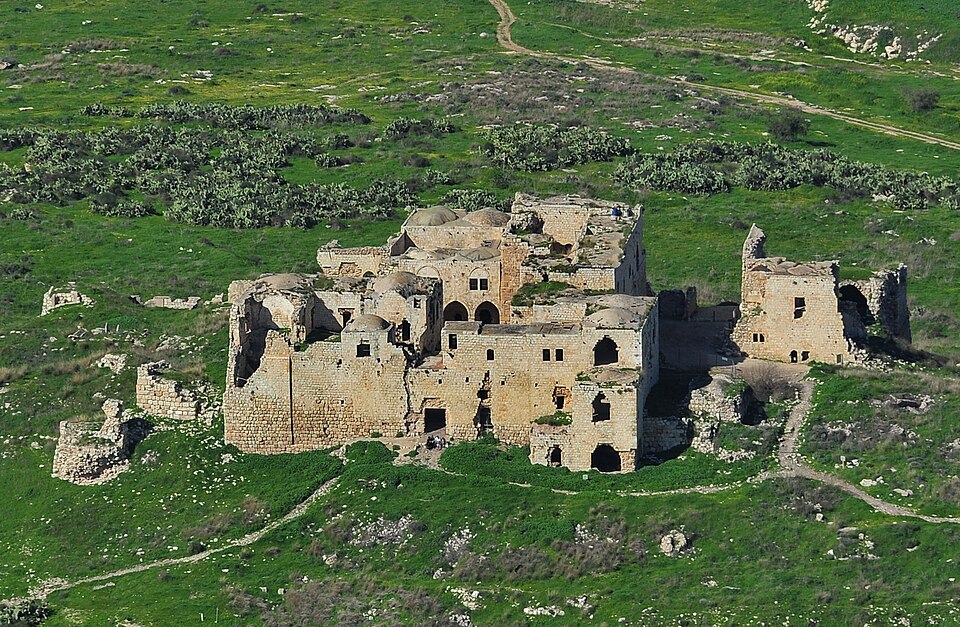
On a hilltop where the Samarian foothills meet the coastal plain, the weathered stones of Migdal Tzedek still command the horizon. This Crusader fortress — known in its heyday as Mirabel — has watched over the ancient highway below for nearly nine hundred years. Armies, caravans, and pilgrims all passed through the narrow corridor at its feet, and whoever held this hill controlled the route between the coast and the interior. Today, the restored ruins sit quietly above the town of Rosh HaAyin, offering visitors one of the finest panoramic viewpoints in central Israel and a layered story that moves from Crusader knights to Mamluk governors to an Ottoman-era sheikh collecting tolls from passing travelers.
Mirabel: The Crusader Castle on the Hill
In the early 12th century, during the expansion of the Crusader Kingdom of Jerusalem, the Ibelin family — one of the most powerful noble houses in Outremer — built a fortified castle on this commanding hilltop and named it Mirabel. The Latin name, meaning “beautiful view” or “wonderful sight,” was no exaggeration. From the summit, the view stretches westward across the entire coastal plain to the shimmering line of the Mediterranean, and eastward into the rolling green hills of Samaria. To the north and south, the landscape unfolds in a sweeping arc that makes the military logic of the site immediately obvious: no army could move through this corridor without being seen from Mirabel’s walls.
The fortress was part of a chain of Crusader strongholds designed to defend the kingdom’s eastern frontier and control the ancient Via Maris — the coastal highway that had carried trade and armies between Egypt and Mesopotamia for millennia. Mirabel’s position was particularly strategic because it overlooked the pass where this highway squeezed between the hills and the marshlands fed by the nearby Yarkon Springs and Tel Afek. The Ibelin lords governed this territory as a seigneury, collecting revenue from the road traffic and maintaining a garrison that could respond quickly to threats from the east.
The Fall and Destruction of Mirabel
The Crusader hold on Mirabel came to an abrupt end in 1187, when Saladin’s decisive victory at the Battle of Hattin shattered the military backbone of the Crusader Kingdom. In the aftermath, Saladin’s forces swept through the lowlands, capturing fortress after fortress. Mirabel fell to Saladin’s brother, al-Adil, who converted it into an Ayyubid military base. The fortress had changed hands, but its strategic value remained unchanged — whoever controlled this hilltop controlled the road below.
The situation shifted again during the Third Crusade. In 1191, as Richard the Lionheart’s forces advanced southward along the coast, Saladin ordered the demolition of Mirabel and several other inland fortifications to prevent the Crusaders from reoccupying them. It was a scorched-earth strategy: if the fortresses could not be held, they would not be left intact for the enemy. Mirabel was reduced to rubble, and for nearly a century, the hilltop lay in ruins — a strategic position without a garrison, its broken walls slowly swallowed by the landscape.
Mamluk Reconstruction and Later Abandonment
The fortress found new purpose in 1266, when the Mamluks — the powerful military dynasty that had replaced the Ayyubids and crushed the last Crusader strongholds — rebuilt portions of the structure. The Mamluk sultan Baybars, who was systematically dismantling Crusader power along the coast, recognized that the hilltop still commanded the road to Jaffa and the coastal plain. The rebuilt fortress served as a military waystation, part of the Mamluk network of fortifications and postal relay stations that connected Egypt with Syria.
However, the Mamluk interest in Migdal Tzedek was relatively short-lived. By the end of the 13th century, the fortress had been abandoned once more. With the Crusader threat eliminated and the coastal highway secured under Mamluk control, the hilltop outpost lost its immediate strategic urgency. The stones of Mirabel — already rebuilt once from Crusader rubble — settled into a second long sleep, slowly crumbling through the centuries as the political focus of the region shifted elsewhere.
Sheikh al-Sadiq and the Name “Migdal Tzedek”
The ruins came back to life in the mid-19th century under unexpected circumstances. Around 1850, a local figure named Sheikh Muhammad al-Sadiq al-Jamma’ini took up residence among the crumbling walls and rebuilt enough of the structure to create a functional stronghold. The sheikh used his hilltop perch for a time-honored purpose: collecting tolls and taxes from travelers passing below on the road between Jaffa and the interior. A small village grew around the rebuilt fortress, and the site became known as Majdal al-Sadiq — the “Tower of al-Sadiq,” named for the sheikh himself.
When the site was later given a Hebrew name, Majdal al-Sadiq became Migdal Tzedek. “Migdal” is the Hebrew word for tower, and “Tzedek” means righteousness. The Hebrew name carries a poetic resonance — “Tower of Righteousness” — though it derives not from any moral quality of the fortress but from the personal name of the sheikh who last occupied it. This layering of names is itself a small history lesson: a Crusader castle called Mirabel becomes an Arab village called Majdal al-Sadiq, which becomes the Israeli national park called Migdal Tzedek. Each name reflects the people who claimed the hilltop and the language in which they understood their world.
The Hilltop Today: Views and Trails
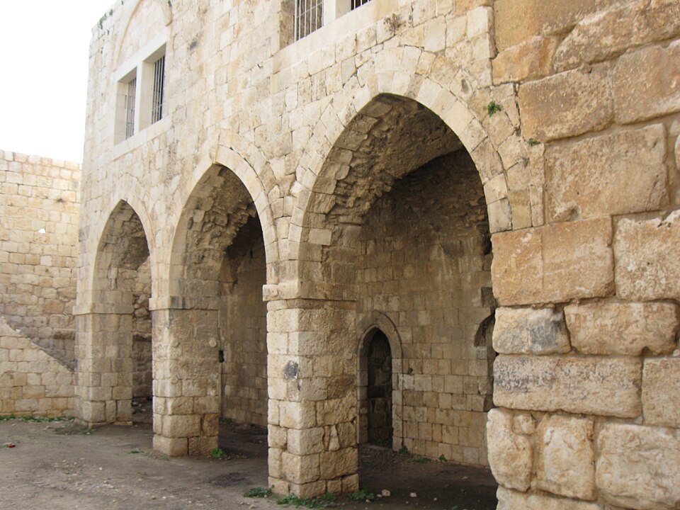
After years of careful restoration, Migdal Tzedek is now a national park managed by the Israel Nature and Parks Authority. The restored fortress walls and tower give visitors a tangible sense of the structure’s original scale, while interpretive signs trace the site’s history from the Crusader period through its Ottoman-era revival. Walking paths wind through the park, passing rehabilitated limestone quarries and the remains of lime kilns that once processed the local stone — evidence of the industrial activity that accompanied fortress life in every era.
But the real draw of Migdal Tzedek is the view. The hilltop offers one of the broadest panoramas in central Israel. On a clear day, you can see the Mediterranean coastline to the west, the urban skyline of the greater Tel Aviv metropolitan area spreading southward, and the Samarian highlands rising to the east. The landscape below tells its own story: the patchwork of fields, orchards, and modern neighborhoods around Rosh HaAyin sits atop the same corridor that ancient caravans once traveled. Standing at the fortress walls, it is easy to understand why every power that controlled this region — Crusaders, Ayyubids, Mamluks, Ottomans — recognized the value of this single hilltop.
Visit Migdal Tzedek with Hoshen Tours
Migdal Tzedek is one of those places that most visitors to Israel never hear about, yet it delivers a remarkably rich experience in a compact setting. The Crusader history, the layered names, the panoramic views, and the quiet trails through restored quarries make it a rewarding stop for history enthusiasts and nature lovers alike. The site pairs naturally with the nearby Yarkon Springs and Tel Afek, ancient Jaffa, Tel Aviv, and Apollonia for a day exploring the central coastal plain. With Hoshen Tours, you get a guide who can bring the Crusader-era rivalries and Mamluk campaigns to life on the very ground where they unfolded. We often pair Migdal Tzedek with the nearby Yarkon Springs and Tel Afek for a half-day that reveals the hidden historical depth of the Rosh HaAyin area — a place where ancient highways, natural springs, and fortress walls converge just minutes from the center of the country. Contact us to build your itinerary.
Explore Our Tour Collection
Explore this site and 65 more in Sacred Steps in the Holy Land
225 pages · The Life, World, and Footsteps of Jesus · Maps, photos, and Scripture references
Ready to experience Israel in true colors?
Plan Your TourPrivate tours designed around your interests, schedule, and pace.